|
Astronomy >> The Celestial Sphere
|
Telescopes >>
|
People have been looking above at the stars since the beginning of time. In the absence of electricity, our ancestors would have spent more time observing the sky above them then they tend to do now. They would have spotted patterns in the stars and noticed the changing positions of the various points of light. They told stories about them and wove myths about the heavens. Some believed that the positions of the stars in the sky had some bearing on both lives and world events. Eventually it was realised that the movements and positions of the stars could be used for navigation, which started the science of astronomy as we know it today.
Our modern understanding of the Solar System is that we live on the third of nine planets that orbit our star, the Sun. The Moon orbits around us. Beyond the Solar System are the vast multitude of other stars that make up the Milky Way galaxy. Beyond that are countless other galaxies. This is the science of astrophysics. However, for observational astronomy and navigation it is far easier to revert back to the Medieval concept of the celestial sphere.
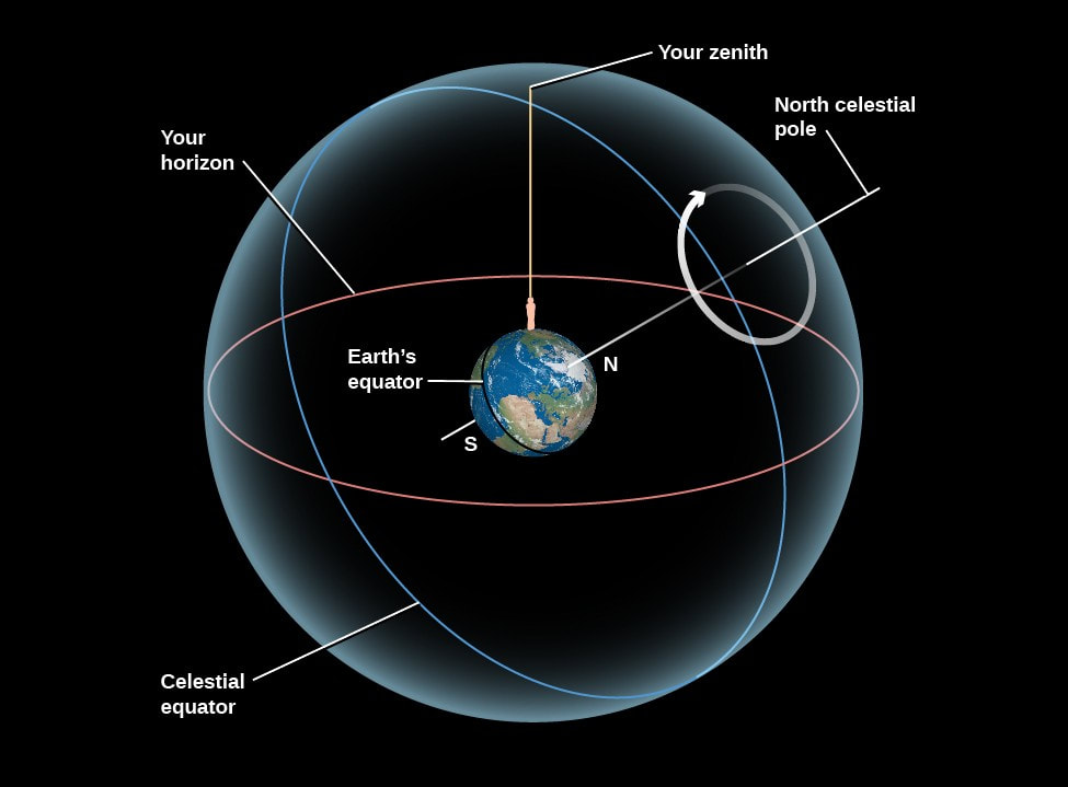
When we look up at the sky we see that the Earth is still and the heavens slowly move above us. This is what the ancients believed and what we experience still today. Reality is that we are on a ball that is spinning on a tilted axis that is also rotating along with others around a fixed star. This can literally make your head spin... So, imagine that the Earth is a stationary ball in the centre of the universe. The stars are 'holes' in a black shell that surrounds us. Inside that shell (or embedded in it) are the heavenly bodies of the Sun, Moon, planets and comets. These are all moving with respect to us and the shell. This shell is known as the CELESTIAL SPHERE. We can imagine it as fixed, and have the Earth spin inside it, or have it rotate about a fixed Earth - doesn't really matter which.
ACTIVITY
- Go outside on a dark night and lie on the ground. Pick a star or group of stars and note their position relative to something fixed (e.g. trees or a roof). After a period of time, you will notice that the positions of the stars has moved slightly. With patience, you will observe that they move a great deal over the course of several hours. With a fancy camera and tripod it is possible to record the motion as shown in the image at the top of this page. These tracks made by the stars are called 'star trails'. The differences in the colours of the stars become more obvious when photographed like this.
- Using the stellarium program, set it to show the celestial sphere - it comes up as a pattern of grid lines. Advance the passage of time by clicking the fast forward arrows. You will see the rotation of the stars that are embedded on the 'sphere'. Scan north and you will notice that the centre of rotation is above the North Pole. In Bermuda the angle from this centre to the northern horizon is \(32^{\circ}\).
|
Definitions
|
Coordinate System
In order to record the positions and movements of the heavenly bodies we need a coordinate system. It mirrors that of the Earth below, but confusingly have different names. The Earth is divided into North-South lines called meridians of longitude and East-West lines known as the parallels of latitude. See Latitude and Longitude for details. Latitude is defined by the angle north or south from the equator, which makes a natural zero reference point. Longitude was more of a problem and since the 19th century has been referenced through the town of Greenwich, which is just to the east of London. This was chosen because of a) the dominance of the Royal Navy and b) the excellent observations made by the Royal Observatory there. There are many interesting stories about the formation of this choice as it provides the universal standard time and celestial reference for the whole world. Due to the rotation of the world, the Sun is overhead at local noon at different times throughout the world. The reference time was set to the average (mean) time of noon at Greenwich. It was originally called Greenwich Mean Time (GMT), but has since been renamed to Coordinated Universal Time (UTC). In almanacs and weather reports it is referred to as Zulu (Z) time. Note that there is a strong relationship between time and angle. This is because our units of time are defined by the rotation of the planet and the motion of the heavenly bodies - they are intertwined with each other.
It is worth getting the hang of this and the whole concept of time zones. There are some excellent YouTube videos on this.
|
|
|
|
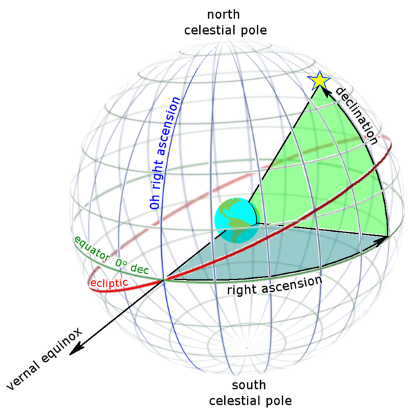
The standard coordinate system on the celestial sphere is also divided into parallels of latitude and meridians of longitude, but they have different names to avoid confusion.
Declination = latitude Right Ascension = longitude The zero point of right ascension is set at the point where and when the Sun is at noon over the equator during the Vernal Equinox (March 21st). This makes a natural and well defined zero point. Also known as the first point of Aries. The track of the Sun across the sky at noon during the year is known as the Ecliptic. It is tilted at \(23.5^{\circ}\) from the celestial equator - which exactly matches the tilt of the Earth's axis from the plane of the Earth's orbit. Again, this is not a coincidence! (Image: Wikipedia) |
|
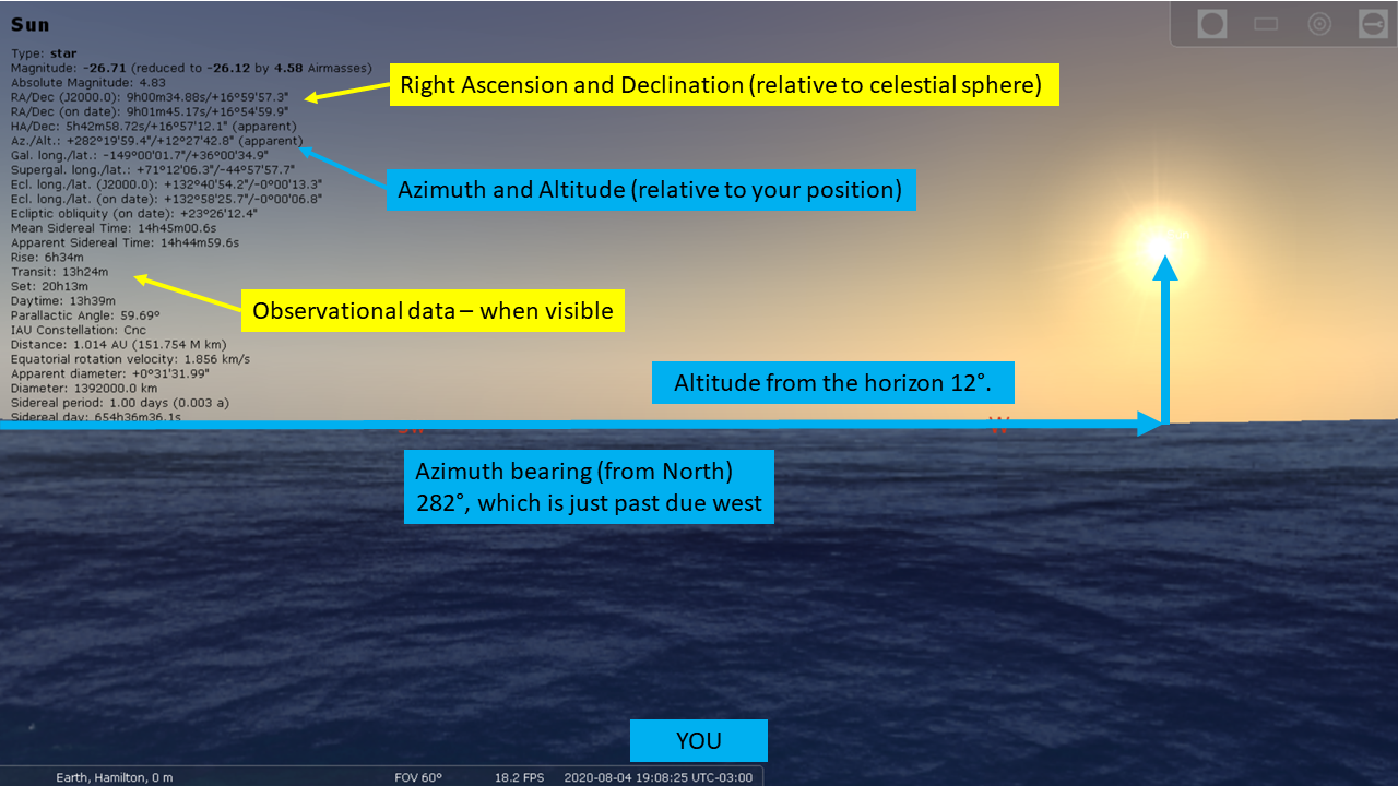
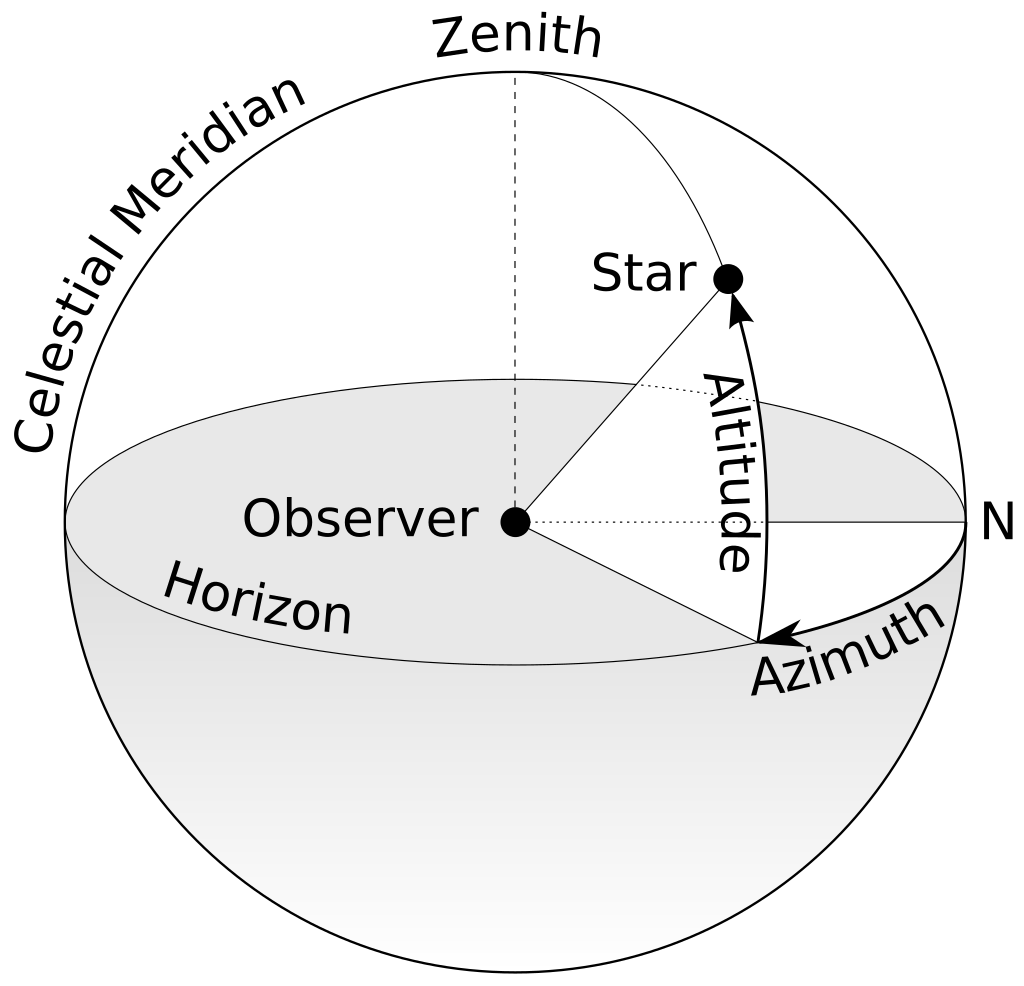
The most useful coordinates for observing are that relative to you - so you know where to look. They are AZIMUTH and ALTITUDE. The altitude is the vertical angle above your horizon and the azimuth is the horizontal bearing from True North. (Image: Wikipedia)
|
ACTIVITY
- Load up the Stellarium program. Scan through until nighttime. Click on any heavenly body and a list of numbers will appear. Look for the coordinates of that body. Top Tip: change the landscape format to Ocean as that gives a clearer horizon.